Pan-sharpened vegetation indices for Kwamtili
Kwamtili Estate blog
Kwamtili Estate in Tanzania's East Usumbara Mountains is dominated by a forested mountain peak and bordered to the south by a forest reserve, to the east by the Muzi River and to the north and west by small holdings and isolated villages. The estate's cocoa is grown in small areas under the forest canopy over much of the foothills of the mountain (see description).
Encroachment and to some extent the activities of baboon colonies are major threats to the forest and cocoa. Monitoring and the early warning of illegal or disturbing activity is essential as much of the forest and cocoa growing areas are difficult to access and sparsely inhabited. The estate's former workers are grouped into an association that provides security. Its members (representatives of 15 familiies living in Kwamtili village that lies just outside the estate) patrol regularly, but their capacity to react is limited. All of Kwamtili's forest is classified by law and is therefore subject to surveillance by the Tanzania Forest Services Agency. However, the authority's resources are also limited and highly extended.
Kwamtili Estate uses the Sentinel2 satellite's 10-metre resolution multispectral data to generate vegetation and other indices for change detection since high-resolution panochromatic imagery is generally unavailable.
A recent review for Kwamtili, which is located some 60 km west-north-west of Tanga on the Tanzania coast some 100 km south of the Kenya-Tanzania border indicates the following for close to or sub-one metre panochromatic satellite imagery:
- SPOT and Pleiades recent archive imagery is not available (see availability at www.intelligence-airbusds.com/en/4871-ordering) , although tasked imagery , i.e., needs to be ordered, may be available at a price that approaches a level that might not be too expensive for an East African venture such as Kwamtili Estate Ltd. Using the Sentinelhub Dashboard, commercial third-party SPOT and Plaiedes imagery prices start with packages at EUR 100 for Pleiades imagery at 8.k EUR/sq.km and SPOT at 0.9 EUR/sq.km. To access the prices, sign in to the Sentinelhub eo-browser; under "Commercial data", there is a link to the Sentinelhub Dashboard sign-in.
- Maxtor Worldview imagery is not available (see discover.digitalglobe.com for availability) and tasked imagery is prohibitively expensive (for e instance, from Sentinelhub, starting at EUR 16.5/sq.km).
- Planet SkyNet: the package starting price is USD 15000 p.a. for 50 images; see planet.com/explorer for availability and orders for tasked imagery.
Those working on government-funded projects in the US and France, and possibly elsewhere, may of course benefit from free access or reduced rates.
NICFI imagery
The only posibility for enhancing the resolution of 10-meter indices generated using Sentinel multispectral data is to use Planetscope imagery. Fortunately, the NICFI (Norway's International Climate and Forests Initiative) Imagery Programme is funding access to Planet Basemap Services for 64 developing countries in tropical regions (see Planet's announcement). Monthly visual mosaics (panochromatic images made up of mosaics of large geotff grid tiles called "basemap quads") with a resolution of 4.77 metres at the Equator are released as visual basemaps each month and approximately one month after acquisition. As an example, the visual basemap for August 2021 is called Planet Medres Visual 2021-08 Mosaic. The visual mosaics are accompanied by data-ready analytical mosaics, called Planet Medres Normalized Analytic 2021-08 Mosaic in the case of August 2021.
This note describes using the NICFI visual basemaps to pan-sharpen 10-metre indices for Kwamtili Estate's forest and cocoa growing areas generated using Sentinel2 multispectral data.
NICFI visual basemaps
We used originally Planet's NICFI Programe Resource Center at developers.planet.com/nicfi which described the NICFI programme. Level 1 access for "individuals and organizations using the data in pursuit of the NICFI Purpose". It allowed downloading. Planet's user quide for third-party participants (called Level 1 users) for what Planet called the NICIFI Data Programe (PDF). The updated NICFI Satellite Data Program may be the follow-on.
Level 1 sign-up is at planet.com/nicfi. One needs to use a different email address to an address that may already be assigned to a Planet account. It is unclear just how much vetting of the submission for access is carried out. For Kwamtili Estate, it was made clear in the online submssion that the estate has a large area (1000 hectacres) of virgin tropical forest adjacent to a forest reserve in a region of exceptional biodiversity value, and that the estate is managed in association with a Switzerland-based service club (UsitawiNetwork). Acceptance was essentially immediate.
Once acceptance was received by email, the sign-on to Planet at planet.com using the email address used for the NICFI programme redirects to the Planet Explorer. Links to the NICFI basesmaps are listed in a drop-down at the bottom-left. The link to the visual basemaps is titled PS Tropical Visual Monitoring. Clicking this link brings up an image map of the tropics with tools to select the area or point of interest. The MyAccount link at the top-right gives access to a user's Planet API key.
NICIFI Basemaps are best explored using Panet's Basemap Explorer (planet.com/basemaps), the link to which is via the Applications drop-down at the top-right of the Planet Explorer.
Once one has signed up to the NICFI and obtained an API key one can use a key to obtain a list of the web addresses for the monthly visual and analytical basemaps that are available (the URL is of the form https://api.planet.com/basemaps/v1/services?api_key=a0a0a0a0a0a0a0a0a0a0a0). Both WMTS and XYZ services are available.
Downloading NICFI basemaps is fairly straightforward. The plugin user's guide (PDF) gives details for downloading using QGIS. A QGIS plugin is required (see integrations/QGIS), called Planet QGIS Plugin v2.1 in Planet documentation, and Planet Explorer in the QGIS Plugins -> Manage & install ... dropdown.
Installation introduces a Planet log-in button in the QGIS menu that brings up the Planet Explorer window at bottom-right. The Explorer has two tabs: Basemaps allows selection of one of the four types of basemaps (PS Tropical Visual Monthly Monitoring was chosen in our case). The Daily Imagery tab allows selection of a quad. One needs to draw an area of interest on a map. The easiest is to add a OpenStreetMap layer to QGIS and to select this layer in the QGIS filebrowse under XYZ Tiles. Selection of a basemap appears as an item added to an Order button in the Explorer window. Clicking the Order button gives access to downloading the quad (the quad geotiff appears in the QGIS main window or is downloaded via an Order Monitor panel at the bottom left).
Pan sharpening Sentinel2 indices
Very briefly, to generate say a pan-sharpened NDVI (normalised difference vegetation index) map, SNAP is used to with the Sen2Res plugin to super-resolve to 10 metres the Band 8 of a standard Sentinel2 S2A_MS1L2A Level 2 package downloaded from the Copernicus Open Access Hub (or as a LC1 Level 1 package from the US EarthExplorer which requires Top of the Atmospheric corrections using the Sen2Cor SNAP plugin). Images of Bands 4 and 8 are then subset to the same size as the Planet basemap quad, exported and copied to QGIS where the GRASS i.pansharpen module is run for both bands (after re-projection to EPSG:4326) using the Planet basemap quad as the high-resolution panochromatic channel. The rasters of the two pan-sharpened bands are then used to calculate the NDVI index which can, for example, be classified into equal interval coloured classes, re-projected to EPSG:3857 and used to generate tiles using QGIS's Generate XYZ Tiles. It should perhaps be noted that Top of the Atmospheric corrections to Sentinel2 can be done in QGIS using the Semi-Automatic Classification plugin as described).
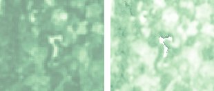
These images (for June 2021, on the left, 10m resolution; on the right, pan-sharpened) compare the NVDI for an area of about 600 m by 500 m centred on Kwamtili Estate's dam (the white, inverted L-shaped area at the centre). Pan-sharpening to 4.77 metres gives a significant improvement in the resolution.
Updated 19 September 2023